This article first appeared in the Autumn 2015 edition of the Dinghy Cruising Association’s (DCA) journal. Photos from the cruise can be seen via the gallery below.
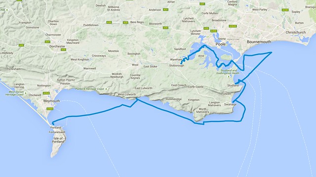
Friday 26th June 2015, 18:30. Driving past the White Horse above Weymouth, Russ Haley and I saw our first view of the bay and Portland Harbour. This is always a welcome sight and today the evening sky was blue and the sea flat. Finally, our coastal cruise was happening. Given the planned cruise’s length, this had been disproportionately long in the planning. Having owned Mallory, my BayRaider Expedition, for 3 years and read about so many cruises in the DCA’s journal, I had long wanted to tackle a cruise where we actually went somewhere. However, with no cruising experience and living by a coast with few landing places and numerous tide races I was nervous. Having left it too late last year when early autumn gales made the trip impossible, this year we were organised for the last weekend of neap tides in June.
A short while later we dropped down to the causeway behind Portland Harbour, where we were to launch, and were met with fog. Sea fog, thick and heavy despite the sun’s attempts to illuminate it. The sea was still cold after a cold spring and fog had rolled in since our first view of the harbour. We quickly rigged the boat, confident the breeze would clear the fog as easily as it had arrived. However, when my wife drove off with the trailer, with a promise to be at Wareham to meet us two days later, the fog remained and we couldn’t see the harbour breakwaters. Sailing tonight would be foolish. Rather than attempting a passage to our planned anchorage in Mupe Bay we took the tame option of mooring the boat in Portland Marina and headed to the bar.
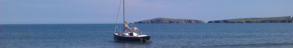
By morning the fog had cleared, the rising sun was shining over the stern and the wind was a light south westerly. I filled the boat’s water ballast tank. Conditions didn’t look challenging but given the nature of the cruise it would be reassuring to have a self-righting boat, plus with a full tank Mallory is stiffer and punches nicely through waves. Just before 07:00 we slipped our mooring and, as is so often the case, sailed on a broad reach for Portland Harbour’s east ship channel.
Despite this being my home sailing area, it always takes longer than expected to cross Weymouth bay. Seen over the bay’s water the white chalk mass of White Nothe is foreshortened. However, we eventually left the Nothe behind and were sailing past chalk cliffs. These have a gentle undulating profile where the vertical cliffs have truncated dry valleys. But the scenery soon changes where the chalk is replaced by limestone cliffs of Purbeck and Portland stone. We sail past Durdle Door and Lulworth Cove, both of which are so striking on land yet deceptively hard to spot from the sea. Finally, after 2 hours 45 minutes easy sailing we put in our first gybe, cleared the chain of Mupe rocks and tucked in to Mupe Bay where we dropped anchor.
The Kobra anchor took some time to set and didn’t fill us with confidence. Whether that was the fault of the anchor, the sea bed or the crew we couldn’t tell but we were glad not to have faced this problem in fading light the previous night. Perhaps the fog had been fortuitous. We had a slow breakfast and relaxed in the sun. There was no rush because the weather was good and the tide wouldn’t turn at St Aldhelm’s head until early afternoon.
Eventually we left Mupe Bay and made a mental note to sleep there at anchor one day. Soon the coast changes again and we were sailing past cliffs of dark Kimmeridge clay, overlain at Gad Cliff by impressive and dramatic overhanging harder rocks. When seen from the sea it isn’t hard to understand why this is known as the Jurassic Coast and is a World Heritage Site!
For the past few hours the bulk of St Aldhelm’s head had been growing and getting clearer. It was now close and our minds turned to think about the St Aldhelm’s race. While not as famous as the nearby Portland race, the headland’s projection in to the Channel combined with a long underwater cliff causes a significant race, confused seas and standing waves. The usual route is to pass 7 nautical miles offshore but an inshore option is possible when conditions enable a passage close enough to the cliffs. We planned to take the inshore route and hoped for a straightforward passage given the neap tides and force 4 south westerly wind.
As we passed the headland it didn’t feel comfortable to sail so close to the cliffs, but we were sailing well alongside the rock faces 100m off our port side. The sea state rapidly changed to a following swell of about 2m between peaks and troughs. That was combined with confused waters and peaks seemingly coming from all directions. The tide hadn’t yet turned but we were in the last hour of the westerly flow and the current was relatively weak. We were still sailing on a broad reach but getting closer to a run and, given the following swell, had raised the centreboard to reduce the chance of a broach. Large waves were occasionally overtaking us but we generally remained on their faces and occasionally surfed down.
Beyond St Aldhelm’s head the coast changes again. Grassy downland abruptly ends in low, sheer limestone cliffs. There are no landing places and this is a wild section of coast. The cliffs are punctured by multiple square caves left over from when the stone was quarried and this adds to the coast’s barren nature. By now the VHF was alive with rescues, including a number of maydays, in the Solent. It was only later that we realised the Round the Island race was underway and, as ever, it was sobering to hear the Coastguard coordinating the rescues.
The sea state eased a little but we were still running ahead of a following sea with reasonable swell. We gybed thinking we could sail closer to a broad reach on that tack but in practice this didn’t make much difference. There are further tide races at Anvil point and Peveril point, although an equal danger at the latter is hitting the ledge that causes the race. To avoid these we continued to sail east, without much northward progress, until east of 1° 55′ W, and then headed due north until beyond the ledge. Our route was probably overly cautious but for a long time we couldn’t see the red can buoy on Peveril ledge and we wanted to stay safe.
The wind had picked up while we were running and we now sailed a fast beam reach with the sea occasionally kissing the starboard gunwale. Finally north of Peveril ledge we beat in to Swanage bay. We had made good time and wanted a break after 3.5 hours sailing since leaving Mupe.
Swanage was a scene of British summer tranquillity. The sun shone, children played on the beach and rowers sweated as they raced in a regatta. We picked up an empty swinging mooring that seemed to belong to a boat called “Keep off”. What an unusual name for a boat! Time for lunch, a snooze and to enjoy bobbing about having completed the challenging part of today’s sail.
An hour and a half later we had left Swanage for the short sail to Studland Bay. We were back sailing along high chalk cliffs, the same seam of chalk that we had last seen at White Nothe and once extended to the Needles and the Isle of Wight before its erosion by the sea. These cliffs finish, or start for those heading clockwise on the South West Coast path, at Old Harry rocks. Once clear of the underwater rocks that extend beyond these sea stacks we swung west in to Studland Bay. This is where we would anchor and sleep before continuing to Poole harbour and Wareham.
We beat through sunny yet blustery conditions to the sheltered southern end of the bay which held a mass of moored sailing and motor boats. Having checked that none of the visitors’ mooring buoys was available we pondered for some time on where to anchor. Then it dawned on us that we were a shoal draft boat and needn’t stay far out with the yachts. Tiredness was obviously taking its toll!
We continued towards the beach and suddenly left the anchored boats behind and entered a virtually clear strip of water between the yachts and the shore. Here were only a few day boats and they were soon to leave. Having anchored in just a couple of metres of water off Redend Point, where a patch of trees onshore gave us complete shelter from the westerly wind, we had a brew, ate and chatted as the sun disappeared in a fine sunset.
Sunday brought light winds, still from the west, and the sun was now generally hidden behind high clouds. Today’s first challenge was to enter Poole harbour, hopefully avoiding the chain ferry. But the ebbing tide would now be running hard through the narrow entrance so we needed to wait until the brief flood that would accompany the second high later that morning. This area’s unusual double high tide would help us enter the harbour despite the tide generally ebbing until mid-afternoon.
After a pleasant couple of hours cruising off Bournemouth, and agreeing that next time we might extend the cruise east to Christchurch and the Solent, we beat back to the harbour entrance. We planned to enter the harbour via the East Looe Channel, but became increasingly concerned when we couldn’t find any of the buoys marked on the chart. We gave up and decided to use the main Swash Channel, heading a good distance south before cutting across to the ship channel such that we didn’t cross Hook Sand. On route we did see pairs of buoys that seemed to mark another channel to the harbour and later research proved that this was the East Looe Channel. It had moved and here was a salutary lesson in keeping charts up-to-date!
We approached the harbour entrance with light and fading winds. At least the tide was with us. From some distance out we timed how long the chain ferry took to cross the entrance and how long it remained moored. That helped us time our entry with confidence and we passed uneventfully in to Poole Harbour.
There are two very different sides to Poole harbour. The east is busy with boats, moored and under way, and has an urban backdrop. But, of course, this is where to find the wide and deep channels. Our choice was to sail the western side via South Deep. This is a narrow channel, with the water depth quickly reducing as soon as you leave the marked route. But this makes for interesting sailing and, combined with the beautiful, unspoilt scenery where you only ever see a handful of boats, this was an obvious route for us.
We beat up South Deep against a foul tide and the wind faded further. It started to rain and wind became ever more unreliable as we approached the shelter of a headland. But we were making progress and if we could only sail round the next few turns we would reach more open water and start sailing on a beam reach. That thought and sheer bloody-mindedness kept us going and once west of Green Island the wind gradually strengthened and our progress became ever more purposeful.
By the time Brownsea Island was well astern we had survived with the centreboard only touching seabed a couple of times. The wind increased further and we now powered to the upper reaches of Poole harbour.
North of the Arne peninsula we turned south west and started beating again. The wind was now a force 5 and the tide was running hard down the Wareham Channel. Here there are large ships moored in the middle of the channel, making the usable channel annoyingly narrow at a point where the tide was running hardest. Progress was slow and we worked hard to gain ground while always keeping a respectful distance from the moored barges. Eventually we cleared the moorings and were now looking straight to the upper reaches of the harbour where it meets the rivers Frome and Piddle.
The wind was blowing hard down the Wareham Channel and a tough beat ensued. But despite this and the foul tide we were making good progress. However, very soon the lack of water and the narrowing channel meant each tack was frustratingly short. Back and forth we went and I was once again grateful for Mallory’s self-tacking jib. We maximised the length of each tack by watching the fish finder closely. Regardless of the channel markers we sailed until the depth was under 2m, knowing from earlier in the day that we touched the seabed when the sounder reported 1.2m. That sometimes allowed us to go well outside the marked channel. But as the channel narrowed the tacks got shorter so we reduced our margin of safety and sailed until the sounder read 1.3m. After each tack we held our breath hoping the depth would increase again as expected.
Just north of Giggers Island the channel bed was so steep at its edge that at the end of each tack we were within a few metres of gulls standing on mud. We only brushed the mud once or twice and eventually approached the harbour’s limit after relentless short tacking. A later check of the GPS showed we had tacked just under 40 times during this beat and most tacks had been satisfyingly close to 90 degrees. We had sailed where others were motoring but now felt we had achieved what we wanted and before entering the river Frome it was time to drop sails and start the engine.
We left the open water of Poole harbour and entered the lower tidal reaches of the river Frome where the narrow river is fringed with tall impenetrable reed beds. Soon we reached boat moorings and, inevitably, discussed the boats we liked, scoffed at the ugly boats and wondered how some had become so neglected that the GRP could hardly be seen for algae. Finally we reached the small slipway at Redcliffe Farm and Nikki, my wife, was waiting with the trailer. The water was now below the concrete slipway and we jumped out on to river bed and rocks, but even loaded with water ballast Mallory’s draft is inconsequential and, having opened the ballast drains, we recovered to the trailer.
We may only have sailed for 2 days and slept on the boat for 2 nights, but the 53 nautical miles had taken us through a wide variety of beautiful scenery and some really enjoyable sailing. Having proved that we and the boat could tackle a coastal cruise, and having found it so much fun, the conversation now turned to the next cruise.
Envious!
Glad you enjoyed Poole Harbour so much Jonathan. I must head from there up to your neck of the woods one day. The Wareham channel has grounded me several times, once for over two hours with a crew who wanted to get back to dinner. They never let me forget about it. One rule of thumb to apply is that if you can see the seagulls’ legs underneath them, it is probably getting a bit shallow…